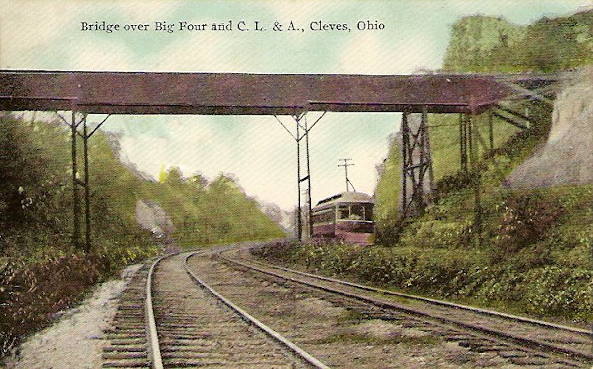
CL&A-Cincinnati, Lawrenceburg & Aurora
Electric Street Railroad
Anderson Ferry - Aurora, IN, branch to Harrison
1900-1930
Standard Gauge
Constructed by the Cincinnati Lawrenceburg
& Aurora Electric Street Railroad, 1900
Reorganized as the Cincinnati
Lawrenceburg & Aurora Electric Railway Company, 1928
Purchased by Cincinnati Street Railway, service
cut back to Fernbank, line from Anderson Ferry to Fernbank
converted to broad gauge, 1930
Streetcar service suspended, 1941
This interurban was a standard-gauge line along the
Ohio River from Anderson's Ferry, at the west end of Cincinnati,
to Aurora, Indiana (25 miles), with a branch from Valley
Junction to Harrison, Ohio (8 miles). It was completed in 1900.
Plans for extension west to Rising Sun, Madison, and Louisville
were never implemented. In 1913 flood damage forced the road
into receivership, from which it did not emerge for 15 years,
one of the longest receivership periods in the industry's
history. The line is principally noteworthy for its pioneer
purchase of lightweight, one-man equipment in 1918. The company
was severely handicapped by its remote terminal, but like the
rest of Cincinnati's standard-gauge interurbans, it never
achieved entry into the center of the city. After reorganizing
as the Cincinnati Lawrenceburg and Aurora Electric Railway
Company in 1928, the line survived for only two years, and was
abandoned in 1930 after a year of operating losses. Six miles
from Anderson's Ferry to Fernbank were converted to 5'-2 1/2"
gauge and operated by the Cincinnati Street Railway until 1940
[actually 1941]. The lightweight cars were sold to the Sand
Springs Railway at Tulsa, Oklahoma. (From: Hilton, George W. and
John F. Due, The Electric Interurban Railways in America.
Stanford University Press, 1960)
The life of many interurbans can look
relatively straightforward when distilled into a single
paragraph. Some smaller companies, such as the Lebanon &
Franklin or the Springfield & Xenia, did have
relatively simple and uneventful lives. Their financing,
construction, and operational history may be of little note to
anyone besides local historians or electric railway
enthusiasts. These companies operated on the same route from
start to finish, made no changes to power facilities, and ran
their original equipment to the end. The Cincinnati, Lawrenceburg
& Aurora was not that sort of company. It was so fraught with
poor planning, operational difficulties, and bad luck over its
30-year life that nearly a third of its track was rerouted at one
point or another, and the majority of that happened only within
the first three years of operation. They were an innovator in
economizing operations when the industry started to falter, and
they experimented with novel freight hauling operations. None
of these developments could have been foreseen when the CL&A
was first incorporated on October 24, 1898 under president John C.
Hooven, George H. Helvey, G. A. Rentchler, C. E. Hooven, and Fred
D. Shafer.
In the early planning stages, a prospective interurban company
would look for the easiest and least expensive route to serve as
many customers as possible. Unlike steam railroads which
need shallow grades, gentle curves, and room to accommodate long
trains, interurbans could work with steeper hills, tighter curves,
and very short passing sidings. The local nature of their
business meant they could not afford extravagances like tunnels,
major hill cuts, long bridges, or extensive fills and
trestles. Operating over public highways and bridges also
afforded significant capital savings, despite the operational
constraints imposed by such arrangements.
 |
|
A CL&A car is crossing the
Great Miami River on the ca. 1884 highway bridge. The
single-track Big Four Railroad's bridge is visible to
the right, which reused the supports from the Cincinnati
& Whitewater Canal aqueduct from the late 1830s or
early 1840s. Both of these bridges were destroyed
by the flood of 1913, which washed away every bridge
over the Great Miami between the Ohio River and Dayton.
The horse and wagon are on Valley Junction Road, which
sits on a part of the canal the railroad elected not to
use.
|
For the CL&A, the most advantageous route to
Lawrenceburg was along the Ohio river, which was relatively populous and
flat compared to a route over the agricultural western hills and its
steep embankments. They run west from the end of the existing streetcar
line at Anderson Ferry. The major obstacles between
Anderson Ferry and points west were the Great Miami River and its
floodplain, as well as the narrow North Bend Hill that separates
the Ohio and Great Miami valleys. Running exclusively along
the flat Ohio River valley directly to Lawrenceburg was not ideal
since it would bypass populated areas like Cleves and
Elizabethtown, and it would also require a
long bridge and extensive earthworks or trestles to cross the
meandering mouth of the Great Miami River. Deviating from the Ohio
Valley however
required crossing the short but steep North Bend Hill to Cleves
before striking out to the west. Company planners determined
that North Bend Hill was the lesser of two evils.
While a continuous route along the Ohio River to Louisville was a
laudable goal, it was well beyond the reach of the company. Rising
Sun was the initial planned terminus, however Aurora and
the Dearborn County Commissioners refused to grant the company
permission to
cross the George Street Bridge over Hogan Creek, having declared
the
iron bridge unable to handle the additional weight. Materials
which had already been ordered for that route, including one block
of track already laid on Main Street to 2nd Street, were torn up
and redirected to a branch line to Harrison instead. This
branch needed to cross the
Great Miami, then it would follow the Big Four Railroad and their Whitewater Division to the north along
Kilby Road.
What was the best way across the
river? The original highway between Cleves and Hooven on the west bank of
the Great Miami River was today's State Road/Henderson Kupfer
Drive. An old wooden truss bridge, which may have dated to as
early as the 1830s, crossed the river near today's BMX bike track
in Gulf Community Park. After that bridge was washed out by the
flood of 1883, a new steel truss bridge was built upriver just to
the north of the Big Four Railroad bridge. These
two bridges were on somewhat higher ground than the old State Road
crossing. The CL&A obtained a franchise to cross this highway
bridge for their branch line to Harrison.
How would the main line get from Cleves and North Bend to
Lawrenceburg and Aurora? There was no direct highway between
Cleves and Elizabethtown to the west near the state border, so if
they decided to extend their main line past Valley Junction at
Kilby Road, the CL&A would need to purchase a right-of-way,
cross the Big Four Whitewater Division tracks, build an extensive
fill or
trestle to stay above the floodplain of the Whitewater River, and
build a bridge over the Whitewater itself. Instead, they elected
to build a short trestle over the Big Four near the border of
Cleves and North Bend, at what was deemed Cleves Junction, then
follow what is today Miamiview Road to Lawrenceburg Road and the
Lost Bridge to Elizabethtown. The Lost Bridge was a covered
wooden Howe truss on stone piers that was built in 1866. It
got its name because the original construction contract did not
include the earthen fill on the Elizabethtown side of the river,
so it was rendered useless and thus "lost" until nearby farmers
filled the approach themselves. The name may also stem from
its rather isolated location and lack of traffic even today, which
led to some stories of wayward surveyors and county assessors
unable to locate the bridge to inspect it. Nonetheless, this
bridge allowed the CL&A main line to cross the Great Miami and
also
avoid the Whitewater, whose confluence with the Great Miami is
about a half mile upstream. The tracks then followed the old
Louisville Pike, now US-50, Oberting Road, and Ridge Avenue to
Lawrenceburg.
Arrival in Lawrenceburg was no simple feat
either, however. The route via Ridge Avenue allowed the
company to serve the community of Greendale and its distilleries
while avoiding the low-lying and sparsely populated floodplain to
the east. It also meant that the route nearly bypassed
Lawrenceburg, since Ridge comes in northwest of town, and the road
to Aurora turns off prior to entering Lawrenceburg. So a
spur track had to be built to Walnut Street in order to reach the
center of town, which required cars to backtrack nearly a mile on the
way to or from Aurora. This is similar to the IR&T Suburban Traction
spur track in Mt. Washington, though much longer. The
in-and-out movement took 12 minutes, which greatly irritated through
passengers.
Operations began on April 12, 1900 between Anderson Ferry and the
carbarn in North Bend. The opening of the CL&A greatly
improved access to the city for Cincinnati's most remote
neighborhoods. Delhi, Sayler Park (Home City before it was
annexed), and Fernbank all grew up as railroad commuter suburbs in
the late 19th century in proximity to bustling industry along the
Ohio River and both the Big Four and B&O
railroads. When the CL&A was
built it added yet another set of tracks through this narrow
linear corridor hemmed in by the river and steep hillsides. Towns
farther out also benefited from more frequent service and
lower fares than were available on the older steam railroads. Two
weeks after opening, operations were extended west of the carbarn
to Cleves, and service reached Lawrenceburg on June 1. The
tracks to Aurora were also complete, except for the bridge over
Tanner's Creek on the west side of Lawrenceburg. A car was
shipped across the creek by the B&O Railroad, and it operated as
a shuttle from Aurora starting on June 4. Passengers would
have to walk over the old wagon bridge to waiting cars until the
CL&A's own bridge was completed. The Harrison branch was
opened on July 4, 1900 to much fanfare.
 |
|
A CL&A car shares the cut
through North Bend Hill with the Big Four Railroad. This
cut was originally constructed in 1888 for the Big Four
to bypass the old Cincinnati & Whitewater Canal
Tunnel to the east. It was widened in 1903 to allow the
CL&A to relocate off of Miami Avenue, and again in
1959 to relocate US-50 off of Miami Avenue. The Harrison
Avenue bridge that once connected to Cliff Road is
overhead. It was demolished as part of the US-50 project
in favor of a new overpass at Brower Road to the south.
|
Construction was typical for the Cincinnati
area, with double track from Anderson Ferry west to the edge of
Fernbank, where it became single track. Rails were generally to
one side of the highway in rural areas, and in the middle of the
street in towns. Due to operating mostly on level ground and
avoiding rivers as much as possible, there were few cuts,
fills, or bridges. The terminal area at Anderson Ferry is quite
far removed from downtown Cincinnati, however, so a long 40 minute
streetcar ride was necessary to reach Fountain Square. Since the
company elected to use standard gauge cars, they had no way to
extend service closer to downtown over the incompatible street
railway tracks. This was an interesting choice because for the
first 20 years of operations, the CL&A offered no freight
service whatsoever, and they didn't interchange cars with steam
railroads. Had they used broad gauge tracks, they would at least
have had the opportunity to run their passenger cars to downtown
over the street railway. When the CL&A was
constructed however, the management of the Cincinnati Traction
Company did not want interurbans running over their tracks, and they preferred to set up transfer hubs at the end of the
streetcar lines.
The power station and carbarns were located on the east side of
North Bend on River Road, a little ways east of Ohio Avenue/St.
Annes Drive, almost at the exact center of the system and with
easy access to various coal depots. Nevertheless, the total length
of the system was at the limits of transmission distance for 600
volt DC power, and several additional feeder wires were needed to
maintain adequate power at Anderson Ferry, Aurora, and
Harrison. Since the electrical system was barely adequate to
begin with, no retail power was sold to customers along the way,
unlike some other companies who did so to diversify their
revenues. Eight 44-passenger double-ended cars equipped with four
motors on 33-inch wheels were the initial equipment roster. These
cars weighed 25-26 tons each and were geared for 35 mph free
running. A 1907 census report of street and electric railways
mentioned 12 passenger cars and one sweeper car on the
roster.
Soon after operations began on the CL&A, some specific
operational challenges became apparent. As early as 1901 it
was clear that the Lost Bridge was a liability due to settling of
some of the piers and abutments, and cracks developing in
structural members due to the weight of heavy interurban
cars. In August, 1901 the CL&A reported that they were
going to abandon use of the bridge, though if they planned to
simply build their own bridge or relocate the entire Miamiview
route is unclear. For the time being they took no action on
this plan.
A few steep grades were also notable issues. Despite the
relatively level river valleys where the CL&A ran, proximity
to hillsides and riverbanks still led to a couple of sub-par
alignments. The first one was at the north end of the trestle
over Muddy Creek, at the border between Fernbank and
Addyston. Almost immediately after turning off of Gracely
Drive at Birch Lane and becoming single-track, the CL&A then
passed over a 900-foot trestle on the way to Main Street in
Addyston. At the end of the trestle there was short but very
steep 30 foot climb to the level of Main Street at what is today
the Harbor View Apartments. This grade proved to be a
hazard, and President Hooven petitioned Addyston to allow them to
relocate their tracks to a private right-of-way behind
the homes on Main Street at the same elevation as the
trestle. The approval was granted by Village Ordinance 227
on or about October 21, 1902, and the new route was put under
construction to West Fork Muddy Creek at 1st Street and Dinning
Lane where the CL&A rejoined Main Street and its original alignment.
The Muddy Creek grade paled in comparison to North Bend Hill,
which was a significant operational handicap for the company. One
of the steepest grades of any streetcar or interurban serving
Cincinnati, traversing the 10% slope between Brower Road and
Harrison Avenue used a great deal of power, and slipping or
runaway cars were serious safety concerns. Despite the
objections of some vocal residents who would lose direct access to
the tracks from their homes, the company obtained permission in
1903 to use the Big Four’s cut through North Bend Hill. This cut was
constructed in 1888 to bypass the former Cincinnati &
Whitewater Canal tunnel which the Big Four had repurposed for
their own use. After the widened cut was complete, the CL&A tracks then diverged from their old
River Road route at Symmes Avenue, and they rejoined Miami Avenue at Mt. Nebo.
That same year, the Lost Bridge burned down,
cutting the main line in half. The fire that destroyed the
bridge in the early morning of July 28, 1903 jump started the plans
the CL&A had been dragging their feet on over the prior two
years. The company was able to strike up another bargain with the
adjacent Big Four Railroad, which allowed them to build an
extension from Kilby Road at Valley Junction to Elizabethtown on
the railroad’s right-of-way. They were even able to share the Big Four bridge over the
Whitewater River with the use of a gauntlet track. The Miamiview route
was torn up, and the rails and ties were most likely reused to build the new
connection. Cleves Junction was removed, and Valley Junction
(sometimes called Harrison Junction to differentiate it from the
Big Four's junction of the same name) became the new branching
point. Track in the highway between OH-128 and Valley Junction was
relocated to a private right-of-way as well.
 |
|
Remnants of the CL&A power
house after a massive fire in 1915. Note the car
and tracks to the left, and the Ohio River in the
background.
|
After the troubles of 1903, the CL&A
settled into a fairly steady operation. Ridership was
average for the Cincinnati area, with 1.5 million passengers in
1912. That said, the C&LE
and Cincinnati & Hamilton
interurbans were by far the strongest in the Cincinnati Area,
serving more than 4.3 million passengers each, so the CL&A
actually took third place in ridership out of nine main routes
spread among seven companies. The populated outer
neighborhoods, heavy industrial employment, and several towns in
relatively close proximity boosted passenger numbers. The branched
nature of the system allowed the company to operate cars on a 30
minute schedule between Anderson Ferry and Cleves, with
alternating cars providing hourly service to Aurora and Harrison.
Despite the amicable relationship with the Big Four, the
CL&A did eventually have to move the Valley Junction -
Elizabethtown route onto its own right-of-way and also build their
own bridge over the Whitewater River, though when that was done is
unclear.
It appears that shortly after CL&A began operations, the
adjacent Big Four saw them not as a competitor, but an opportunity
to dispose of their own commuter operations. While long-distance
passenger service remained profitable for mainline steam railroads
for decades, the short-haul, peaky, and uni-directional nature of
daily commuter operations were a hassle to serve at best and
unprofitable at worst. They were, however, never able to
completely shed this service until after the CL&A was
abandoned and Union Terminal opened in 1932. All passenger
trains were required to use the new station, but it was
unacceptably far from downtown for commuters, and most if not all
railroad commuter operations ceased upon its dedication. Prior to
that time however, the wider station spacing and more
convenient terminal location at 3rd Street and Central Avenue made
trips to downtown faster on the Big Four, though they had few
off-peak trains and higher fares than the traction line.
Nonetheless, they still went out of their way to accommodate the
CL&A, defying the usually hostile practices of most mainline
steam railroads east of the Mississippi River, most notably the
Pennsylvania Railroad. This was perhaps
because the CL&A offered no freight competition, but possibly
also due to the underlying corporate structure of the Big Four which
eventually became part of the New York Central. They had an open-door
management policy that encouraged employees to freely discuss
job-related issues, share ideas, and voice concerns directly with
management or executives. Such a structure would be more amenable to
cooperation with junior railroads. This is in stark contrast to the
Pennsylvania Railroad that maintained a highly regimented, strictly
hierarchical, inflexible, top-down management style that bordered on
militaristic. This clash in management style would be one of several
factors in the ultimate failure of the Penn Central merger.
Anyway, a benefit of the company's original route
along Miamiview would become sorely apparent after the devastating
flood of 1913. Every bridge over the Great Miami River from Dayton
south was destroyed, along with the CL&A and Big Four bridges
over the Whitewater River. Much of the Harrison
branch was inundated or washed out as well since it closely
followed the Whitewater River. The CL&A could only operate from Anderson
Ferry to Cleves while extensive repair work and new bridges were
constructed. Temporary wooden pile structures were built to keep
the railroads and highways open while permanent spans were built.
The expenses and lack of revenue caused a loss of $100,000 and
President Hooven petitioned for receivership under Frank B. Shutts
of Miami, Florida. Had the Lost Bridge not burned down in 1903, or
if the County had been more expedient in replacing it (its successor
wasn't opened until 1906, and every time this bridge was destroyed
or closed in 1903, 1913, and 1980 there were arguments over
whether it would be replaced at all), the CL&A would likely
have been able to restore operations to Lawrenceburg and Aurora
much sooner. The Miamiview route is above flood level, and only
the half mile of road west of the Lost Bridge on the floodplain
between there and Elizabethtown would have needed rebuilding.
Unfortunately that ship had sailed ten years prior. After
full operations were restored, Shutts resigned as receiver on
December 28, 1914, and Edward Stark was appointed and assisted by
Hooven on January 17, 1918.
Still reeling from the 1913 flood, the
company's power station exploded in 1915. Some question whether
there was actually an explosion versus just a large fire, but regardless
the building was leveled, including the
carbarn and shops. The structure was rebuilt, and some second-hand
cars were purchased from the Chicago & West Towns Railway to
replace those lost in the blaze. By 1917 the company was
purchasing power from Union Gas & Electric, with 33 kV 3-phase
AC power feeding new 200 kW automatic substations with rotary AC
to DC converters. One substation was somewhere in Fernbank, and
the other was next to US-50 just east of the Ohio/Indiana border,
and it is still standing as of October, 2023. How power was
supplied in the intervening two years is unclear, but it does seem
that they rebuilt the power station even if only used for two
years. Either way, the carbarn and shops remained at that location
after reconstruction, and it was used until 1937 as a garage by
the Ohio Department of Highways after the CL&A closed down in
1930.
The building sat derelict until 1959 when it was demolished to
widen US-50.
The year 1918 comes up regularly throughout reports of the
interurban industry as being particularly difficult, where many
companies entered receivership or began talks of abandonment.
Price and wage inflation, virtually unheard of before WWI, ate
into revenues since fares were fixed by franchise agreements that
never anticipated an inflationary monetary system or a major world
war. Maintenance costs for aging infrastructure and equipment was
also rising along with greater competition from automobiles,
buses, and trucks. There were really only two choices that
traction lines had: abandon or modernize. Still deep in
receivership from the 1913 flood and power station fire, the
CL&A chose to modernize in an attempt to restore the company
to profitability and pay down their debts. Since the power system
had already been upgraded, the next step was to purchase new
lightweight one-man cars. These vehicles from the Cincinnati Car
Company were half the weight of their old ones, weighing only 12.5
tons and having 24-inch wheels, which were quite small for
interurban cars at the time. This allowed for level boarding at
platforms and fewer steps up from the street. Since they were half
the weight, they also used half as much power, they didn’t beat up
the tracks as hard as heavier cars, fewer rail ties were needed,
and the cars required less maintenance. They also eliminated the
need for a conductor, saving on salaries, although a second
crewman was still carried between Lawrenceburg and Aurora to flag
at-grade railroad crossings of the B&O in Lawrenceburg at
Walnut and Williams Streets, 3rd Street, and at George Street in
Aurora. By reducing the number of stops, eliminating some street
running, and tightening up layover times at Aurora and Harrison,
they were also able to maintain their running schedule with five
active cars instead of the original six, with two cars kept in
reserve. This move was so successful at reducing operating costs
that other roads in Cincinnati and around the country began
similar programs to modernize.
 |
|
The CL&A was a pioneer in
purchasing new lightweight one-man cars. This particular
one was manufactured by the Cincinnati Car Company,
which also incorporated many of the same techniques into
more modern streetcars. The color scheme for these appears to
have been Pullman green above and below the windows,
cream around the windows with maroon window sashes
and doors, and a gray roof.
|
While the CL&A operated through a highly
industrialized corridor, freight business was nonexistent as
mentioned previously. Industry reports in the mid 1910s show 100%
of company revenue coming from passenger service. Interestingly, a
booklet called Along the Line, published shortly after operations
began, noted the strong farming community at Elizabethtown and
other smaller manufactories along the way that appeared to be good
potential freight customers. That said, the B&O, Big Four, and
river barges were already serving online customers with their own
freight sidings and spur tracks. The milk, fruit, canned goods,
and express shipments that were a mainstay of the industry were likely
also spoken for by the larger railroad companies who could deliver
those goods to downtown Cincinnati in one movement. This lack of a
connection to the downtown Cincinnati market was also cited in one
report as a reason for the CL&A's lack of freight business.
Even if broad gauge cars had been used, the company would likely have
been
limited by the street railway company in the type of freight
services they could provide over their tracks, if any. The whole
reason the street railway used broad gauge tracks in the first
place was to prevent freight trains from running through city
streets after all.
Despite all those obstacles, in an effort to diversify their
revenues, the CL&A became a pioneer in container shipping by
partnering with the Cincinnati Motor Terminals Company. This
operation was born out of the freight hauling paralysis of WWI when
railroads, already operating near their maximum capacity, were
strained to the breaking point from the shift to wartime
operations. Cincinnati was a notorious bottleneck in the nation's
railroad system even before the war, with less-than-carload (LCL)
freight taking multiple days to be transferred between railroads
or to customers in the city. These sorts of small loads, made up
of many different types of freight from different customers all
bound for different destinations were a logistics nightmare, and
handling them through excessive local rail switching operations or
teams of horses pulling trailers made them ridiculously slow and
expensive. All this was on top of a massive freight car shortage
caused by the war, while many routes were completely shaken up by
the change in traffic patterns to delivering war materials to the
east coast for ocean shipping to Europe.
The Cincinnati Motor Terminals Company founder, Benjamin Franklin
Fitch, designed detachable trailer bodies for trucks which allowed
them to be loaded at freight depots as parcels came in, while the
driver could be out picking up or delivering other containers that
were full. Previous trucks and horse-drawn trailers were all one
unit, which required the driver to wait for it to be fully loaded
or
unloaded. Initially delivering only between the various steam
railroad terminals in downtown Cincinnati, this company was able
to move more than ten times the tonnage of the older trap cars
(similar to boxcars) used by the Railroads for LCL hauling. In an
effort to introduce more intermodal shipping, where the containers
could be loaded and moved via not just truck but also train, the
CL&A was approached in 1921 to install hoists and loading
facilities at Anderson Ferry so full containers could be delivered
by truck and then offloaded as necessary along the way to Indiana,
or vice versa. One of the old Chicago & West Towns cars was
modified to remove the body and create a flat platform for two
containers, leaving motorman's cabs intact at the front and
back. A small single-truck flatcar was also outfitted to carry a
container. A few other local railroads dabbled in this type
of operation, such as the C&LE
which also built hoists and had some of their own flatcars that
could carry two containers. Fitch did not have much luck
introducing his trailers to other cities, though he did eventually
have success courting both the Pennsylvania Railroad and New York
Central Railroad. The Great Depression however would take its
toll. Reduced tonnage meant fewer logistics problems, while the
PRR and NYC both implemented their own trucking services and
canceled their contracts. The C&LE stopped hauling trailers in
1935, and in 1937 the Interstate Commerce Commission determined
that rail freight containers for this sort of operation had to be
owned by the shipper, not the railroad, which basically killed it
as a going concern. Motor trucks in general took over LCL freight
hauling all on their own, eliminating the railroads from the
picture. Only since the end of the 20th century has intermodal
cargo shipping really come back, with today's distinctive metal
containers being shipped across the oceans for transloading to
railroad or truck.
Another economizing move made by the CL&A
and other interurbans was to eliminate redundant trackage and shed
street maintenance liabilities. Like the IR&T lines and CM&B
coming in to the
east side of Cincinnati, the CL&A had several miles of
double-track within the city limits and on public streets. In the
case of the IR&T Rapid Railway line, a few miles were
purchased by the street railway company while they were still in
operation, but in most other cases the increase in traffic that
would warrant double track operation never materialized, nor did
the hoped-for buyout by the street railway, which more often only
happened at abandonment. The CL&A thus eliminated all of their
double track, which was only within the city limits in the first
place, and they replaced it with a single track with passing
sidings. They also moved the route through Delhi, Sayler Park, and
Fernbank off of Gracely Drive (then known as Lower River Road) to
a private right-of-way next to the Big Four railroad tracks, much
like it was originally constructed east of Delhi. The new tracks
had to bend around the small railroad commuter stations in these
neighborhoods, and it ultimately swung north and east to meet up
with Birch Lane where it rejoined the existing route into Addyston
and beyond. This track realignment reduced increasingly frequent
altercations with automobiles and motor trucks on Gracely, which
was the main road through those neighborhoods prior to the
relocation and upgrading of River Road to a highway in the 1950s
and 1960s. It also absolved the company of responsibility to
maintain the roadway around their tracks. By the 1920s
municipalities were pressuring interurbans to pave the street
around their rails, if not from curb to curb, which was well
beyond the scope of their original franchises, and it would only
benefit competing automobile, truck, and bus traffic, while
complicating track maintenance. A similar move was made in
Cleves in 1923, eliminating the remaining street running on Miami
and Cooper, and utilizing a right-of-way next to the Big Four
between Mt. Nebo and the highway bridge over the Great Miami Riaver.
Addyston apparently ordered the
company to remove their tracks from Main Street at some point,
because of failure to maintain the street to the village's
satisfaction or pay franchise fees, but it's unclear if this was
ever carried out.
 |
|
The CL&A terminal at Anderson
Ferry Road in approximately 1921, showing Cincinnati
Motor Terminals trailers being hoisted onto a truck, and
the modified car which could haul two such trailers.
From "On the Right Track: Some Historic Cincinnati
Railroads" by John H. White, Jr.
|
While the economizing moves and introduction of
freight handling helped the company's finances immensely,
operating across state lines and through several municipalities
made raising fares in the face of price and wage inflation more
difficult than for other companies. Extension to downtown to
allow either one-seat passenger service to Dixie Terminal, or to
connect with the Cincinnati subway that was under construction in
the early 1920s, was well out of financial reach of the
CL&A. The West End Rapid Transit Company was chartered
as early as 1915 to build this connection, including a mile-long
viaduct over the Mill Creek Valley to span the tangle of railroads
beneath. Private financing dried up during World War I and
in 1920 the Rapid Transit Commission rejected a petition to put a
$1 million public bond issue for the project on the ballot,
leaving the CL&A stranded at Anderson Ferry for the remainder
of its independent life.
By the late 1920s the benefits of modernization had worn off, and
the company's fortunes were looking bleak. A report was
prepared in 1927 for the Cincinnati Street Railway in
consideration of purchasing the company. They recommended
the Harrison branch be abandoned immediately for hemorrhaging
money, since it was serving barely 100 passengers per day. Monthly
operating expenses of the branch line were $2,152.00, more
than five times the revenue of $417.85 from passenger fares. The
CL&A had purchased a bus company that operated between
Fountain Square, Anderson Ferry, and Fernbank in an effort to
control competition, but operating this bus line was at a loss,
and the street railway report suggested only retaining the bus
service between Fountain Square and Anderson Ferry. The
street railway company was not interested in buying out the
CL&A and in 1928 the company was reorganized as the Cincinnati Lawrenceburg & Aurora Electric
Railway Company, closing out their 15 year receivership. Charles H. Deppe, vice-president of the Fifth-Third Union Trust
Company was the receiver, and he was slated to become president
of the reorganized company along with Joseph L. Lackner of the
law firm Maxwell & Ramsay who would become secretary. Samuel I. Lipp would continue as vice-president and general
counsel having been elected prior to this date.
At some point shortly thereafter the CL&A was
purchased or taken over by Lawrence Van Ness, who was primarily
interested in the company's electrical infrastructure, which could
be sold off to growing power companies. He was on the board
of directors according to a 1921 financial report, but his
involvement before the 1928 reorganization is unclear. Regardless,
the eventual closing of the CL&A and takeover by the
Cincinnati Street Railway after final abandonment on November 30,
1930 is similar to what happened with the CM&B on the east
side of town, which was also purchased by Van Ness. The street
railway company originally planned to substitute the service with
buses, but residents along the line wanted to retain rail service.
So the infrastructure was purchased at scrap value for streetcar
use. The track gauge had to be converted from standard to broad,
which was done by leaving one rail and moving the other one out
six inches to the new spacing. Since nearly the entire route was
on private right-of-way after 1918 they didn't have to tear up
streets to modify the tracks. The line was cut back to Birch Lane,
just off of Gracely Drive where it originally went to single
track, and a loop and small electrical substation were installed.
The new route 30 Fernbank opened on January 1, 1931. Since the
standard gauge cars were of no use but still in good shape,
they were sold in 1932 to the Sand Springs
Railway in Oklahoma, which was a latecomer to the interurban
scene, opening in 1911 between Tulsa and Sand Springs. Streetcar service on route 30 was replaced with buses
on June 1, 1941 and the tracks were pulled up for wartime scrap.
CL&A car 918, renumbered 68 by its new
owner, survived until 1955 when Sand Springs converted to diesel
freight operations. That car was obtained by the Illinois
Railway Museum in 1967 and has been restored to its state in the
1950s under Sand Springs, with a bright yellow body,
cream windows, and maroon on the roof and doors. The rest of the
cars purchased by Sand Springs from the CL&A were
apparently scrapped in 1955 or before.
The CL&A terminal at Anderson Ferry
originally met a large streetcar loop with an extra layover track
next to the traction line's depot. The odd frontage street to the
north is where the original River Road and streetcar line ran
before bending slightly south. The CL&A terminal was actually
east of Anderson Ferry Road, but straightening out the road's
alignment paved over the station location in 1948. This sort
of connection was the preference of the Cincinnati Traction
Company, which did not want interurbans running over their tracks
until political pressure or a change in management a bit later
into the first decade of the 1900s. Pretty much all traces of the
CL&A's route within the city were obliterated by the widening
and realignment of River Road in the 1950s. The original double
track route within the city limits basically followed the south
side of the old narrow River Road west from here to Delhi, with
the outbound track on the street and the inbound track off to the
side near the railroad tracks. The rail in the street was removed
when the line was single-tracked in 1918. Upon reaching Delhi, the
line originally merged with Gracely Drive to pass through the
neighborhoods of Sayler Park and Fernbank. After 1918, the tracks
in the street were removed and the whole line paralleled the Big
Four railroad and the now-gone Nokomis Avenue until about 500 feet
past Thornton Avenue where it turned to meet up with the original
route at Birch and Gracely. Birch Lane is mostly unimproved
gravel, but the curbs on Gracely form corners to what was
apparently intended to be a decent sized street.
 |
|
The CL&A Cleves Junction
station was barely three years old when the Miamiview
route was removed and it became a simple waystation. Miami Avenue is to
the left, and to
the right the ground drops off precipitously to the Big
Four railroad cut. The plank sidewalk at the
bottom right is the start of a trestle for the Miamiview
route that crossed the
cut. The building was completely dilapidated by
the 1990s and it was subsequently demolished.
|
The interurban line then ran on its own
right-of-way for a short distance, crossing Muddy Creek on its own
trestle. Originally it took a short but steep uphill to Main
Street from the trestle at what is today the Harbor View
Apartments, but after 1902 it turned to the west at the end of the
trestle and ran behind the houses on Main Street. Graded
right-of-way remains behind those houses before coming onto Main
Street in Addyston at Dining Lane where bridge piers and abutments
remain over the small west fork of Muddy Creek. The CL&A
continued on Main Street through Addyston, then US-50 west of
Bowman Lane. The site of the power house and carbarn was mostly
obliterated by widening of US-50 but it was located in a grove of
trees east of Ohio Avenue/St. Annes Drive, below Sunset Avenue.
Before US-50 was widened and bypassed North Bend to the west, the
highway turned directly onto Miami Avenue, as did the CL&A
from 1900-1903. Cleves Junction was located at 325 Miami Avenue
near Wamsley Avenue, with a small station building and the tracks
to Aurora turning off Miami on the north side of the station.
Tracing the short-lived Miamiview route between Cleves, the Lost
Bridge, and Elizabethtown has proven enormously difficult due to
its short lifetime. Since parts of the CL&A that ran for its
full 30 years are still difficult to spot, trying to find roadbed
that was only used for three years is a significant
challenge. There are no maps and no property records that
indicate the location of this route save for a few descriptions
and poorly captioned photos from the company's Along the Line
booklet. This booklet shows the underpass at Elizabethtown, and
also a photo of private right-of-way just east of “Harold Switch”
which was a passing siding a little ways east of the confluence of
the Great Miami and Whitewater River. A newspaper clipping
from November 1900 notes a head-on collision between two CL&A
cars when one motorman mistakenly went through Harold Switch
without meeting the approaching car due to a misunderstanding of a
schedule change. The collision was apparently in front of
the home of one Dr. Smedley, but that location is also a
mystery. Either way, that was definitely on a private
right-of-way, and the photo looks to be a bit up the hill
too. Regardless, there doesn't seem to be any evidence in
topographic maps, but wooded hillsides tend not to be well
documented in that respect. Earl Clark Jr's research on the route
also suggests a private right-of-way to the south of Miamiview
near the toe of the hill. In the meantime, that's how the
route is mapped, though with many question marks as to its true
disposition.
Back at North Bend, after 1903 the CL&A
diverged from the highway at Symmes Avenue and shared the newly
widened cut through the hillside with the Big Four Railroad past
Harrison's Tomb. The eastbound/southbound lanes of today's US-50
are on the old roadbed after significant widening of the cut was
done to accommodate the highway. The CL&A after 1903 turned
back to Miami via Mt. Nebo and proceeded north through Cleves to
Cooper. It then came back onto US-50 and crossed the Great Miami
River, sharing the old highway bridges. After the 1923 Cleves
bypass was built, the tracks simply continued north past Mt. Nebo
where US-50 runs today. The route to Aurora followed US-50 into
Indiana and Lawrenceburg. Detailed USGS maps of southeast Indiana
from the CL&A operating period have been nearly impossible to
locate, so the routing from the state line through Greendale
should be taken with a grain of salt. Proximity to the Big
Four Railroad and the old Whitewater Canal next to Oberting Road
makes figuring out what was what rather difficult. The CL&A
crossed the Big Four's Greendale cutoff on a short bridge roughly
100 feet east of the current Ridge Avenue overpass in what was
originally a small village called Homestead that was later annexed
to Greendale. The CL&A then ran slightly to the east of
Ridge and came onto the road somewhere around Probasco Street. As
mentioned earlier, the street running in Lawrenceburg was somewhat
bizarre due to the layout of the roads coming into town. There was
a T-intersection at 3rd and Main with a spur into town from 3rd to
Walnut to High Street that required the motorman to change car
ends for the return trip. After crossing Tanner's Creek, Doughty
Lane behind the Family Dollar is the old route. The remainder of
the line to Aurora was on a private right-of-way next to the
highway. It turned onto George Street and ended just short
of the bridge over Hogan Creek in Aurora.
The branch line to Harrison basically
paralleled the Big Four's Whitewater Division, now I&O, along
Kilby Road. North of the I-275 exit Kilby Road jogs from the west
side of the Big Four to the east side, and immediately thereafter
it crosses Dry Fork Creek directly on the CL&A's old
alignment. North of that point there's a bit more space between
today's road and the I&O where the CL&A ran, though it's
just overgrown trees now. There appears to be some extant
right-of-way next to the I&O after Kilby diverges on a due
north tangent away from the railroad, but it's all on private
property with no cross streets. At Campbell Road west of
Kilby was the old Simonson station. After abandonment,
Clarence Roudebush, nephew of Benjamin J. Simonson, a local farmer
for whom the station was named, moved the small wooden station
building to use for storage on his own farm. Around 1980, his
Grandson, Frank A. Roudebush, decided it should be saved and he moved
the Simonson Station to Ann and Gene Woelfels yard at 6590 Kilby
Road. It was restored in 2014-2015 by the Harrison Rotary
Club by request of the Harrison Village Historical Society. West of Simonson the traction line followed the south side of
Campbell until reaching State Road, running up the east side of
the road until reaching town, then moving to the middle of the
street at the heart of Harrison, where passengers could disembark
to either Ohio or Indiana depending on which side of the car they
exited.
Main
Line Photographs from Anderson Ferry to Aurora
Harrison Branch Photographs from
Valley Junction to Harrison
Return to Index